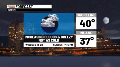
This afternoon is becoming wet and windy!
Steady/heavier rain and strong gusty winds will be around this evening through Monday. We could see 1″ to 2″ of rain with locally higher amounts. WIND ADVISORY for the shore with wind gusts ranging from 20 to 45 MPH & isolated 50 MPH (scattered outages), and a COASTAL FLOOD ADVISORY is up for moderate flooding along the shoreline with water levels 1.5 to 3.0 feet above normal during the high tide cycles. Stay tuned.
Once the storm passes, it will remain breezy with slow clearing on Tuesday. A bright but brisk rest of the week is expected with highs in the 50s-low 60s and some frost inland possibly during the morning hours, later in the week with 30s.


This afternoon: Windy with steady rain arriving through 3 PM. Steady rain and gusty winds are expected tonight-Monday AM. Coastal flooding is likely during high tide from 2-4 PM. Some scattered power outages possible overnight.


Tonight: Some of the heaviest rain and gusty winds, ranging from 35 to 50 MPH! High tide coastal flooding is likely 3-5 AM. Some power, tree issues possible in some spots.
Tomorrow: Rain and gusty winds, ranging from 35 to 50 MPH! High tide coastal flooding is likely 3-5 AM and again between 3-5 PM.


Tuesday: Gradually drying. More clouds than sun. Highs in the low 60s.

Wednesday: Sun and clouds. Seasonable highs in the mid-60s.
Thursday: Partly cloudy with highs in the upper 50s, near 60°.
Friday: Mainly sunny and seasonable with highs in the low-mid 60s.
Saturday: Lots of sun with highs in the low 60s.
Sunday: Some clouds, seasonable with highs in the low-mid 60s.
Source link