A line of showers and thunderstorms are crossing the state from west to east as a potent cold front approaches. Some storms could be severe with damaging winds, hail, dangerous cloud-to-ground lightning, and possibly a tornado. Please stay weather aware if you have outdoor plans! The biggest area of concern is Northern and Western CT for the strongest storms.
Some rain will likely continue through Saturday night and Sunday morning. Sunday mid-late afternoon should be drier and much cooler. Bright and pleasant for the first half of next week!


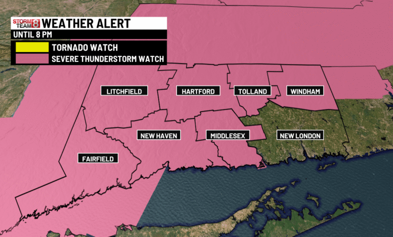
This Afternoon: A SEVERE THUNDERSTORM WATCH is in effect until 8pm tonight for most of the state. Some storms will be severe with damaging winds, hail, dangerous cloud-to-ground lightning, and possibly a tornado. Highs in the low-mid 80s. Stay weather aware!


Tonight: Early severe storm, rain lingering through the night. Lows around 60
Sunday: Rain at times in the morning through early afternoon, gradually tapering off from NW to SE across the state during the mid-afternoon. Much cooler. High 65-70.

Monday: Scattered clouds, delightful with highs in the low to mid 70s. Overnight lows 40s.

Tuesday: Bright and pleasant with highs in the low to mid 70s.

Wednesday: A few clouds, delightful. Highs in the mid-70s.
Thursday: Another quiet, pleasant weather day. Highs in the low 70s.
Friday: A pleasant weather day! Highs in the low 70s.
Saturday: Mainly sunny with highs in the low-mid 70s.. Highs in the low 70s.
Source link