Overnight, it will turn partly cloudy and chilly with lows in the 30s to near 40 degrees. After a bright start on Sunday, clouds will start increasing with yet another fast moving system headed our way! Late in the day and into Saturday night, a line of rain and thunderstorms will push thru the state. Some of the storms will contain heavy rain and gusty winds. Keep your eye to the sky and head indoors if you hear some thunder.
Monday and Tuesday finally feature some very nice weather with highs in the 60s to near 70 degrees before it turns unsettled again mid to late week.
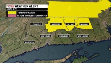
Note: FLOOD WARNING for the Connecticut River until further notice for minor flooding!
Tonight: Early clouds and showers then clearing. Windy at times with gusts to 30 mph. Lows in the 30s to lower 40s.

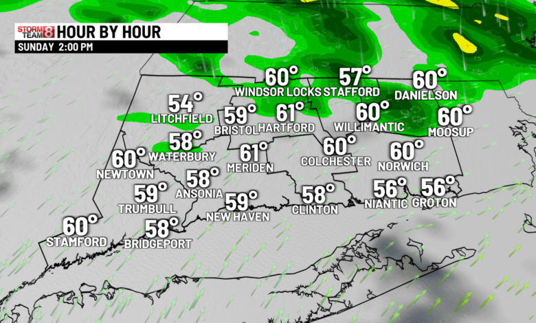
Sunday: Early sun, then increasing cloudiness with some rain and thunderstorms possible for late afternoon into Sunday night. Highs in the low 60s.


Monday & Tuesday: Mostly sunny & pleasant with highs in the mid-60s to near 70.

Wednesday: Lots of clouds with scattered showers developing and mild. Highs in the low 60s.
Thursday: Periods of rain and much cooler. Highs in the mid 50s.
Friday: Partly sunny, breezy with some showers possible. Highs 55-60.
Source link